|
|
|
|
|
Gary C. Kessler
Artificial Reefs in Florida
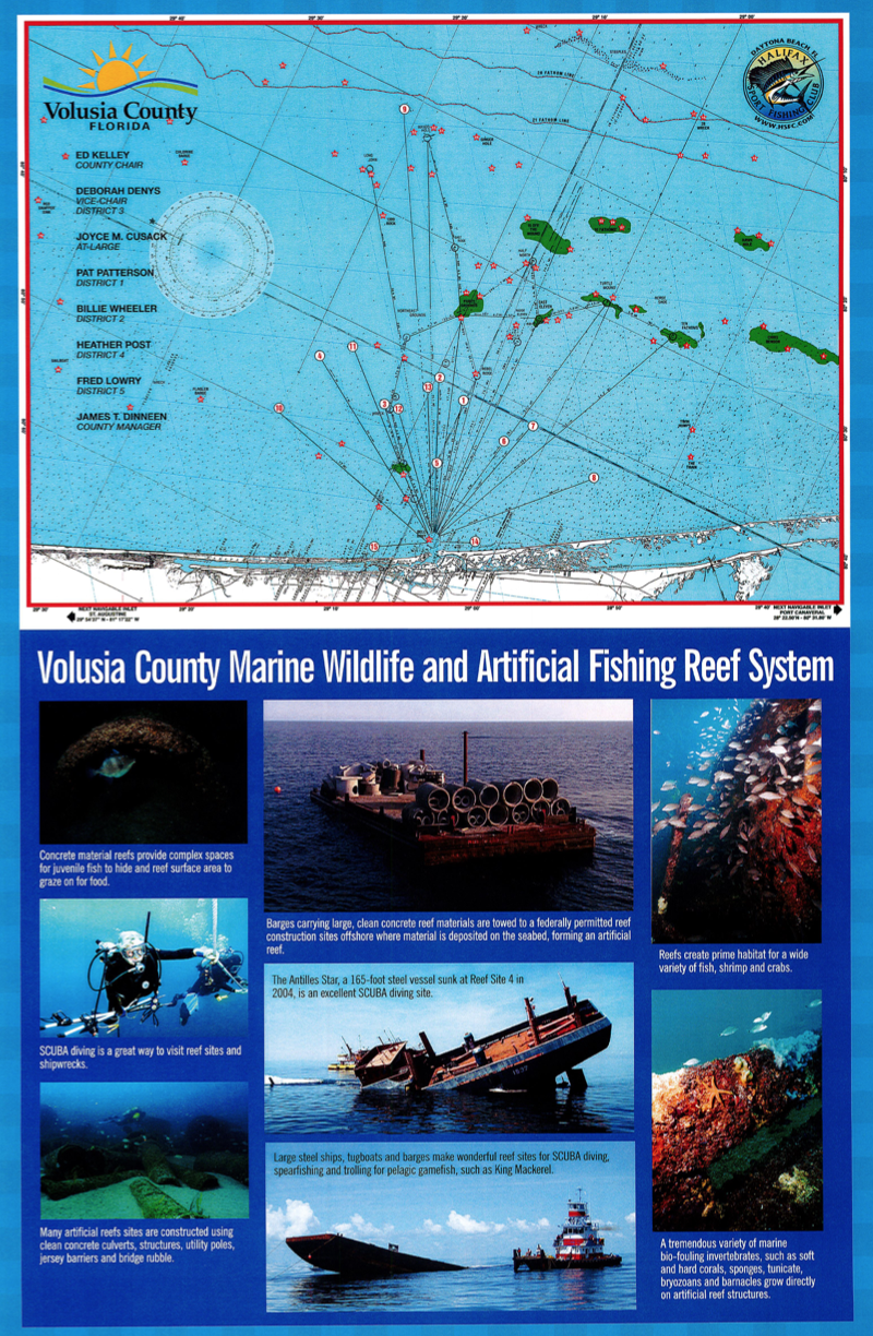
The state of Florida has an extensive artificial reef program; 34 of Florida's 35 coastal counties fronting the Gulf of Mexico and Atlantic Ocean host more than 2,750 public artificial reefs. Some of these reefs date back to the 1940s. Volusia County — home to Daytona Beach, New Smyrna Beach, and Ponce de Leon Inlet — has an artificial reef program established in the 1970s and containing more than 150 drops.
For more information about artificial reefs, see the Helpful Links page at the Volusia County Reef Report.
- Volusia County Marine Wildlife Habitat and Artificial Fishing Reef System
- Wrecks Dropped in 2018
- Wrecks in the Volusia County Reef System
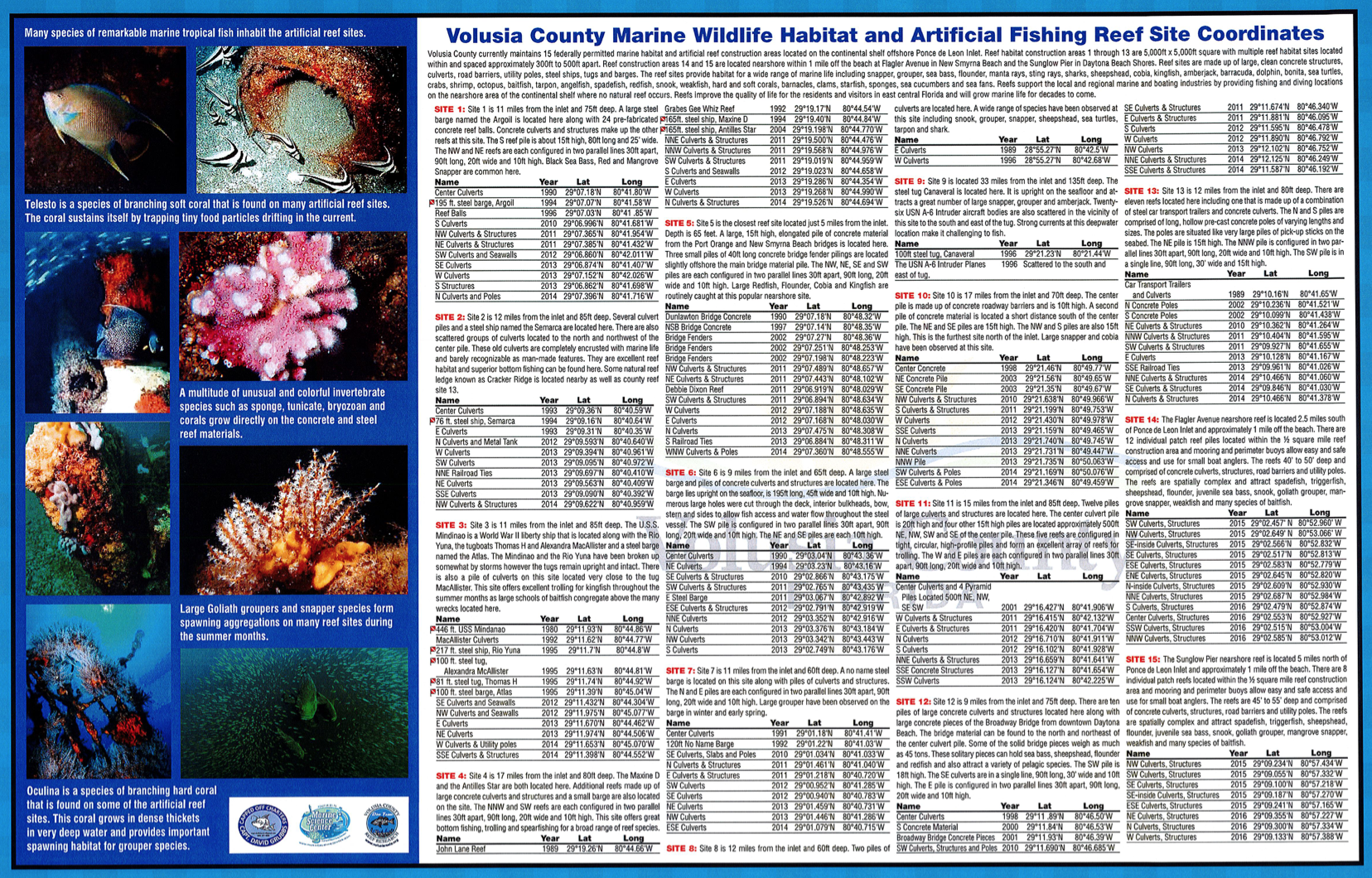
Volusia County Marine Wildlife Habitat and Artificial Fishing Reef System
A great overview of the Volusia County Artificial Reef System can be found at the Building Complexity story map site! More information about the local reef system — including details about each site, GPS coordinates, and reef news — see the Volusia County Reef Report Web site. Click on the images below to see the reef system brochure.
Wrecks Dropped in 2018
On Saturday, June 23, 2018, two ships were sunk to form Volusia County's newest artificial reefs. The 150' M/V Lady Philomena and the 90' Tug Everglades were successfully deployed to the seafloor at Volusia County Artificial Reef Site 12, approximately 9.6 miles from the mouth of Ponce Inlet.
Dinah Voyles Pulver (The Daytona Beach News-Journal) wrote a follow-up article, titled "2 ships sunk miles off coast become Volusia's latest artificial reefs," including this video.
More detailed information is posted at the Volusia County Reef Report:
2018 - Site 12 M/V Lady Philomena
DD MM.MMM: 29°11.582', -080°46.141'
DD.DDDDDD: 29.193033°, -080.769017°
GPS Format Bow (unofficial) Stern (unofficial) DD MM.MMM 29°11.573', -080°46.147' 29°11.591', -080°46.135' DD.DDDDDD 29.192883°, -080.769117° 29.193183°, -080.768917° The M/V Lady Philomena (IMO 5146419, MMSI 677058200), is a 150-foot, 376 gross ton steel cargo vessel, sunk in approximately 75 feet of water. Built in 1956, the Tanzania-flagged Lady P. was acquired by the county soon after it was seized by the U.S. Coast Guard after Miami-Dade narcotics detectives found 47 kilos of cocaine aboard her in March 2017. Donated to the county to become an artificial reef, it cost $100,000 to clean and tow the boat from Miami. The Lady P. had operated under at least ten different names during its lifetime, including Helena, Barbara J, Anglesey Trader, Anudo, and Fortuna.
Chris Dembinsky posted these two videos:
See also The Sinking of the Lady Philomena - Volusia County, FL.
2018 - Site 12 Tug Everglades
DD MM.MMM: 29°11.594', -080°46.176'
DD.DDDDDD: 29.193233°, -080.769604°
GPS Format Bow (unofficial) Stern (unofficial) DD MM.MMM 29°11.590', -080°46.180' 29°11.600', -080°46.170' DD.DDDDDD 29.193167°, -080.769667° 29.193333°, -080.769500° The tug Everglades (IMO 6515875), is a 90-foot, 141 gross ton steel tugboat, sunk in approximately 75 feet of water. The tug appears to have landed with the bow very close, possibly within 10 feet, to the east side of the V12-14-SSE pile, with the bow pointing southeast at approximately 225°. Built in 1956 and decommisioned in late-2016 or early-2017, the boat was cleaned in Fort Pierce and brought to the area in fall 2017. The Everglades had also operated under the names Matton 25 and Joan Turecamo.
Images taken by Chris Dembinsky, taken from a Volusia Co. support boat.
2018 - Site 12 Lady P-Everglades Trail
DD MM.MMM: 29°11.582', -080°46.154'
DD.DDDDDD: 29.193033°, -080.769233°
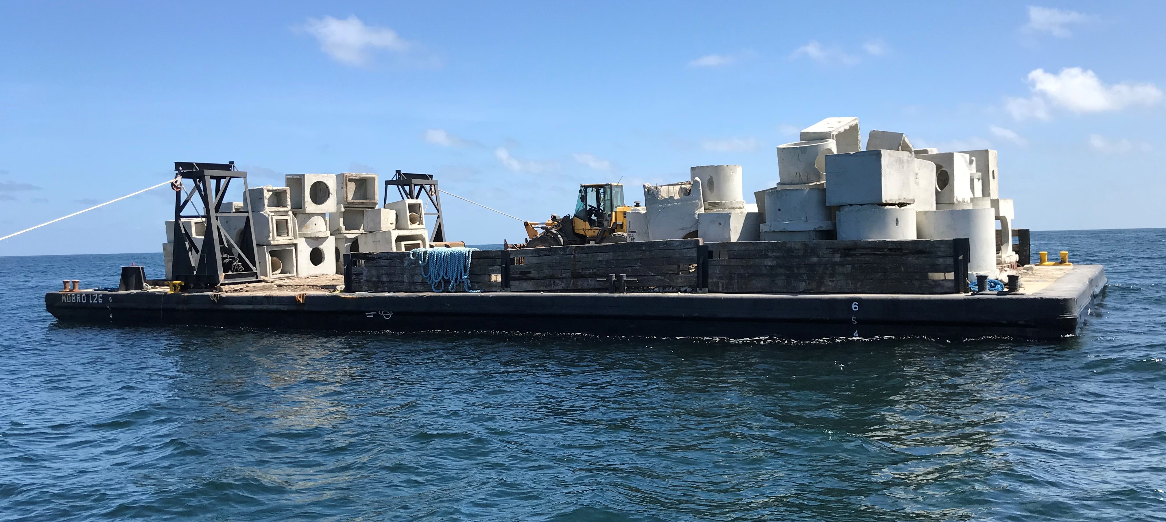
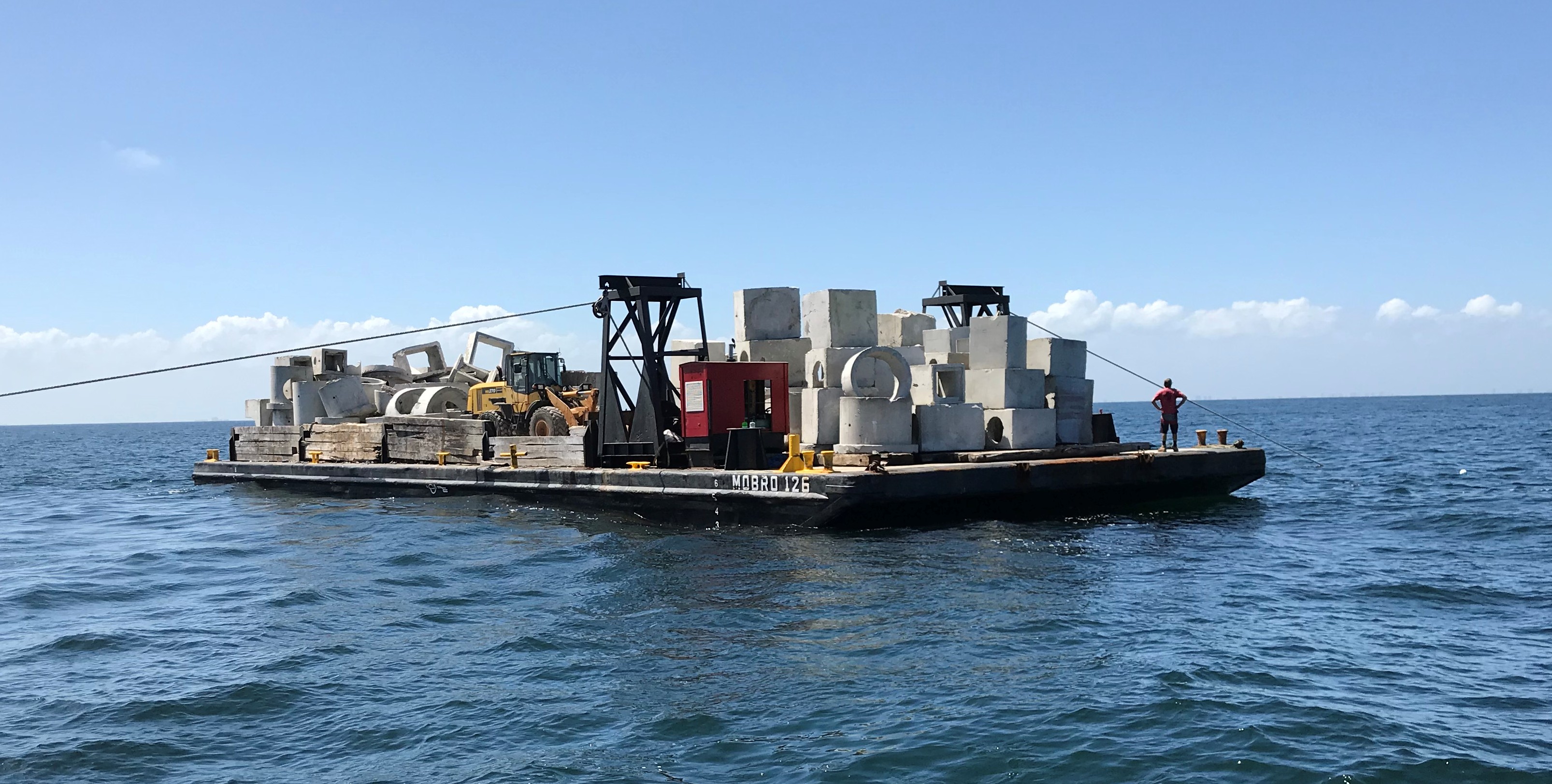
On September 27, 2018, a unique reef deployment was conducted creating a reef trail of large concrete structures between the Lady Philomena and the Tug Everglades wrecks. The trail is comprised of large, clean concrete structures configured in a 175' long line approximately 10'-15' high between the two wrecks. This is the first reef/shipwreck trail in northeast Florida. The coordinates provided here are the approximate middle of the trail.
Photos courtesy Joe Nolin.
See also Everglades Tug Goes Down.
Wrecks in the Volusia County Reef System
The Volusia County Artificial Reef System has a number of wrecks. Here is a summary, with links back to the Volusia County Reef Report site...
- Site 1 (~11 nm from the mouth of Ponce Inlet)
- Argoil (V01-94ESE1) — 195' steel barge
[[ Updated coordinates: 29°07.075', -080°41.601' (29.117917°, -080.693350°) ]]- Site 2 (~12.5 nm from the mouth of Ponce Inlet)
- Semarca (V02-94S1) — 76' steel ship
- Site 3 (~10.5 nm from the mouth of Ponce Inlet)
- USS Mindanao (V03-80N1) — 446' World War II Liberty ship in 85' of water
- Rio Luna (V03-95N1) — Former Caribbean trader
- Alexandra McAllister (V03-95W1) — Tug
- Thomas H (V03-95NW1) — Tug
- Atlas (V03-95SW1) — Barge
- Site 4 (~14 nm from the mouth of Ponce Inlet)
- Maxine D (V04-94NW1) — 165' steel ship
- Antilles Star (V04-04WSW1) — 165' steel ship
- Site 6 (~8.5 nm from the mouth of Ponce Inlet)
- East Barge (V06-11E1) — 195' barge
- Site 7 (~9 nm from the mouth of Ponce Inlet)
- Water Barge (V07-94C5) — 120' x 30' x 7' steel water barge
- Site 9 (~33 nm from the mouth of Ponce Inlet)
- Ship (V09-96C18) — 100' ship
- USN Intruder Planes — Approximately two dozen US Navy Grumman A-6 Intruder jet aircraft
- Site 12 (~9 nm from the mouth of Ponce Inlet)
- Everglades (V12-18EVG) — 90' tug in 75' of water
- Lady Philomena (V12-18LDP) — 150' ship in 75' of water